Coronado Heights Castle, Kansas

Coronado Heights Park is a scenic overlook and park on a 300′ promontory a few miles northwest of Lindsborg, Kansas. In the 1930s, the Works Progress Administration (WPA) built a picnic area and castle like building out of Dakota limestone. It is rather cool and the view is spectacular – reminiscent of the view from Sterling Castle in Scotland.  The winding drive up to the heights is beautiful, with many trees, yucca, and sumac.

The park has grills and fireplaces, including a fireplace in the “castle,” which is otherwise unlighted except for the windows. There are many stone picnic tables located around the edge of hill, with views in all directions. When visited in July of 2007, the castle and grounds were clean and in surprisingly good repair. There is a stone rest room building, but from a distance it wasn’t clear what condition it is in, and it didn’t look like there was a regular path to the rest rooms.

Coronado Heights receives its name from Francisco Vasquez de Coronado, who visited central Kansas in 1541, looking for the Native American community of Quivira, where he was told “trees hung with golden bells and … pots and pans were beaten gold.”

Coronado didn’t find his gold, and it is unknown if he actually ascended the heights now named after him near Lindsborg, Kansas.

There is also a 3 mile mountain bike trail with two loops around the base of Coronado Heights Park.

Take Coronado Avenue (Highway 4) 3 miles north of Lindsborg to Coronado Heights Road (unpaved). Go 1 mile west, just past Smoky Hill Cemetery and turn right at the stone gate. You will see Coronado Heights Park from many miles. Open 8 AM to 11 PM.

Coronado Heights Park was closed for most of the 2019 summer, because of a land slide on the road up to the park, but it reopened at the end of August.

SOURCE: kansastravel.org

Weird Wednesdays: The Cedar Peak Treehouse, Washington

Have you ever wanted to stay in a treehouse?  If you visit Washington, you may have a chance!

I found this article, written by Melissa, who visits and photographs her journeys on her site called Miss Rover.

Where is Cedar Falls Treehouse in Washington?

Cedar Falls Tree House sits on a lovely property named Cozy Acres. This beautiful spot of old growth forest is just outside of North Bend, Washington about 30 minutes East of Seattle. This Washington Treehouse is a very convenient getaway from the city.

Treehouse Details:

2 guests, 1 bed

No Pets

Kitchenette

Composting Toilet

Outdoor Shower

Note: the bed is in a loft with a secured ladder. It was moderately easy to get in and out of the loft space for me.

Amenities

Large Picture Windows

Wrap around deck

Firepit on deck

Outdoor Shower

WIFI

Projector and 100″ screen

Speaker for music

Cooking at the Treehouse

The treehouse provides a small kitchenette with a mini fridge, microwave and Keurig. Outside on the deck, there is a grill and camp stove included with all the basic cooking utensils provided.

We cooked the first night we were there, grilling kababs with a delicious jalapeno sauce.

The Bathroom

I know some people are very particular about bathrooms when staying at more rustic places! This bathroom is small, but very clean with a composting toilet. This specific composting toilet was wonderful. Sometimes they can have really strange/bad odors and this one smelled fantastic, like cedar.

Instructions are provided on how to use the toilet.

The shower is an outdoor shower below the treehouse. Hot water is available through a propane system that was really easy to use. The water heated up really fast and it felt very private and was really a peaceful, luxurious experience for me.

Prices of this Washington Treehouse

As of July 2022, the price to book Cedar Falls Treehouse on Cozy Acres is $290 per night. Also note a 2-night minimum is required(and worth it). This price is without the added cleaning fees and service fee that can vary.

SOURCE: MISS ROVER.com

Bishop Castle: Rye, Colorado

Ever since 1969, Jim Bishop has singlehandedly constructed Bishop’s Castle, which is the largest self-built palace in the United States — and may be the largest self-built architecture project in the entire world.

There were no blueprints or diagrams for the eccentric Bishop Castle in Rye, Colorado. Built by Jim Bishop over the course of 60 years, the monumental structure is the result of his own imagination and lackadaisical building style. As he told one interviewer, “I just build. I don’t measure.”

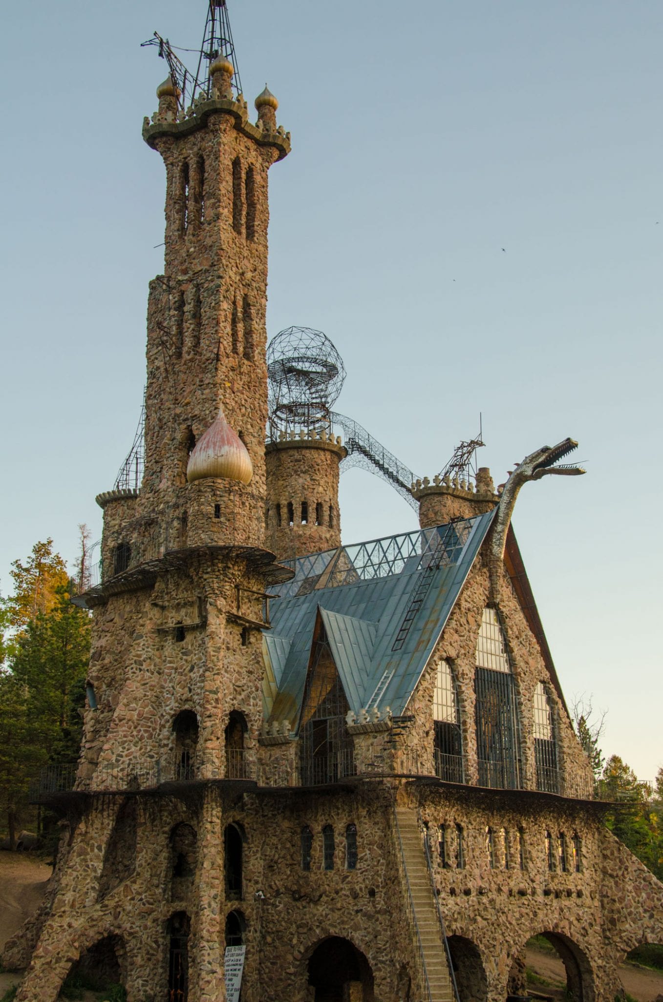
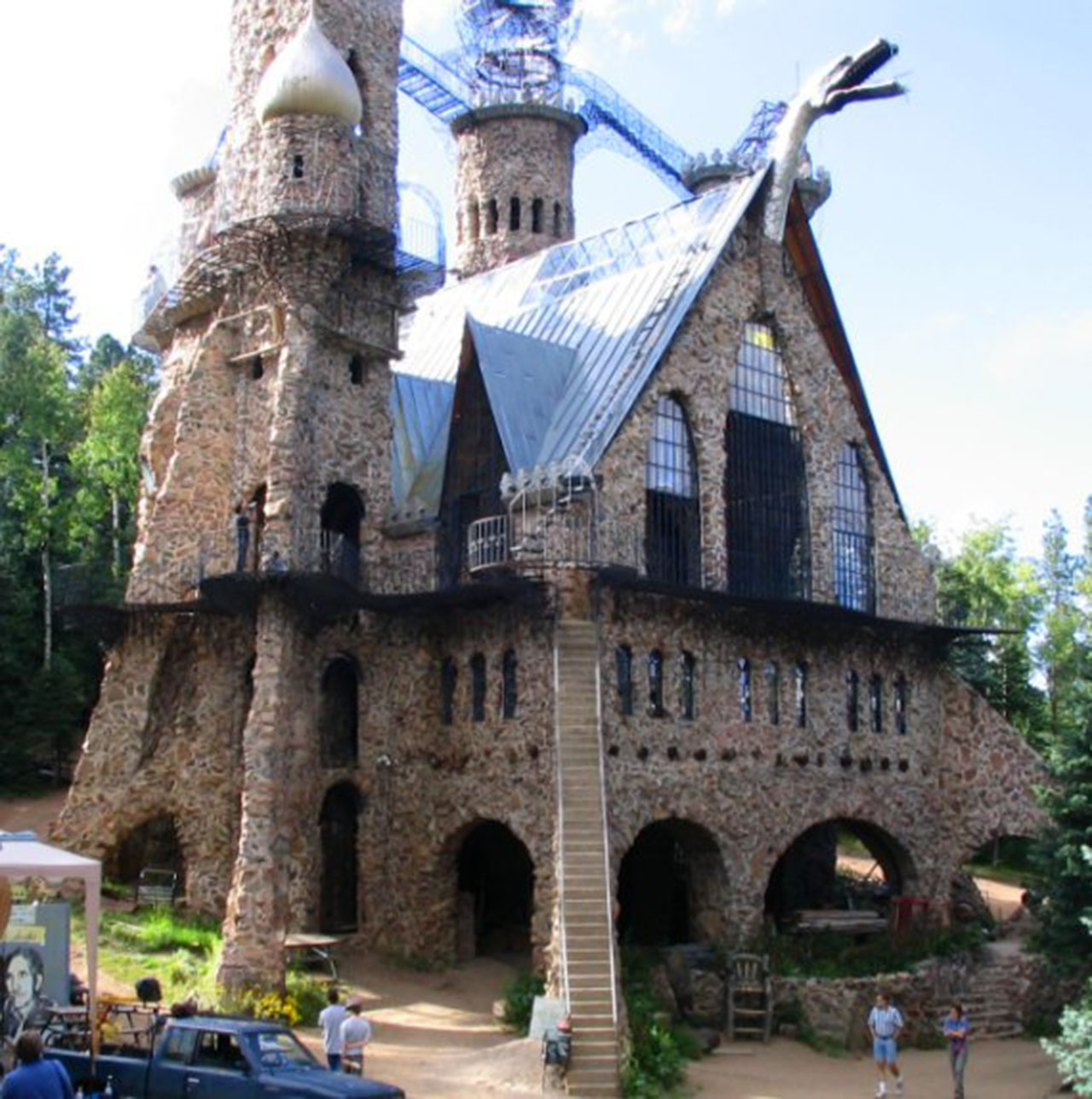
Made of high, teetering bridges and stairs, Bishop’s Castle is constructed on top of what once was his one-room cottage using over 1,000 tons of rock from the nearby San Isabel National Forest.

It is also littered with signs that warn visitors not to excessively shake them or they could collapse, as Bishop didn’t believe in building codes.

Nevertheless, people flock from all around to see Bishop’s Castle — and to marvel at its craftsmanship. Indeed, even though some may be wary of its stability, the beauty of the castle stands on its own merit.

Why Jim Bishop Built Bishop Castle

It was 1959 and Jim Bishop was 15 years old when he fell in love with two-and-a-half acres for sale in the mountains outside Pueblo, Colorado. He had enough money saved for the $450 down payment — of the total $1,250 price — from mowing lawns and delivering newspapers. His parents had to sign the paperwork since he wasn’t legally able to buy the land himself.

His dream was to build a family cabin. For the next handful of summers, Bishop and his dad went camping at the site and made building plans. Those plans remained dreams until Bishop married his girlfriend, Phoebe, and decided to begin building them a place to live.

Taking rocks from the surrounding parkland, Bishop set out to construct a simple, one-room cottage. Building season in the mountains is quite short, however, between snowmelt and snowfall. Bishop and his father alternated weeks; one working on the home while the other ran the family’s ironwork business.

There wasn’t any running water at the cottage, so Bishop had to build a 40-foot-tall cistern for the water supply. When he began constructing it from stone as well, it resembled a castle tower. Neighbors noticed and jokingly asked if Bishop was erecting a castle.

The comments sparked his imagination: Why not build a castle?

Bishop’s father thought this sounded like more work than he was willing to do, and with the main cabin finished, gracefully bowed out and let his son go on building to his heart’s content.

Constructing The Eccentric Palace

Working in his family’s iron shop meant Bishop learned how things came together. He chopped down trees and milled them into lumber. He dug 12-foot foundations and created scaffolding and pulley systems as he went.

According to Bishop, he’d dream up some feature he wanted, build it, and when it was finished it’d spark an idea for the next part of the castle.

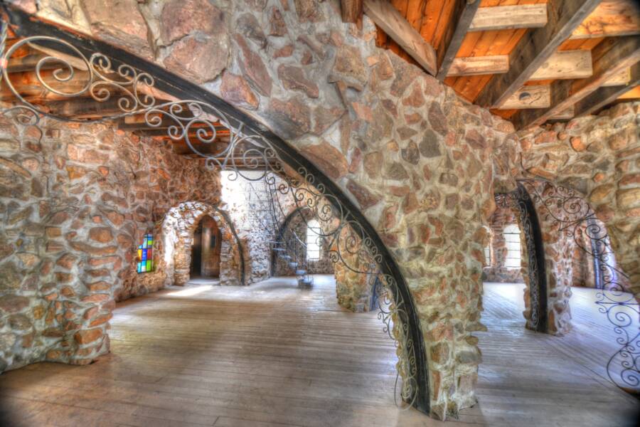
The ironwork arches on the second floor of Bishop Castle are perhaps one of the palace’s best examples of precision geometry. The support trusses are so large that it’s hard to fathom them being put into place by one man. But they were. All of the castle was built by Bishop alone.

He would say Bishop Castle was “Built by one man with the help of God.”

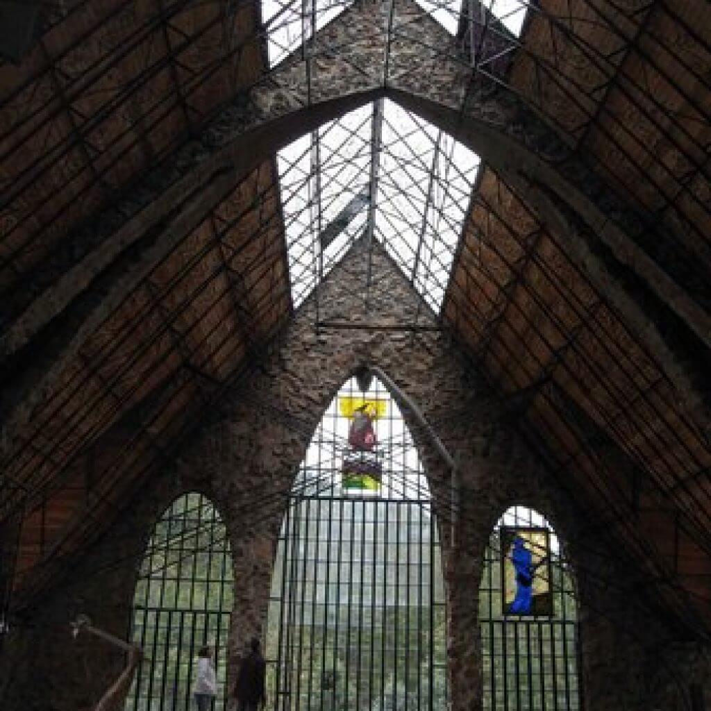
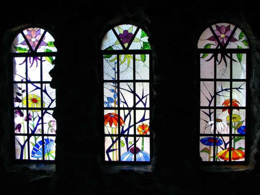
The facade of the building features a fire-breathing dragon made from recycled warming plates and a donated hot-air balloon warmer. The fireplace cleverly ventilates through the dragon’s nostrils. Stained glass windows decorate the palace’s grand hall.

Bishop Castle kept growing, and more visitors showed up to see it, but Bishop never considered charging them admission to enter. Bishop Castle can still be accessed free of charge.

In fact, Bishop drew up legal documents stating that as long as Bishop Castle stands, no one can ever charge admission. However, he did eventually set up a donation box.

Visiting Bishop Castle

Because of its unwieldiness, the Colorado Chamber of Commerce refused to list the castle as an attraction in their pamphlets. There was already some bad blood between Bishop and the state of Colorado, however, as he technically built his palace with rocks that belonged to a national park.

Additionally, no insurance company wanted to be responsible for the ongoing construction at the code-less “attraction.” After he’s gone, Jim Bishop said that he hopes his kids and grandkids will carry on the traditions of the castle.

Today, the castle is 160 feet tall, and construction has slowed considerably as Bishop has gotten older — but will probably not stop anytime soon. His eldest son, Daniel, handles the upkeep and interacts with the visitors. He put his own business on hold to help his parents as they moved into old age. Sadly, his mother, Phoebe, died in 2018.

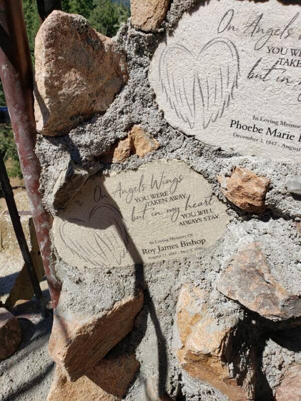
The castle is no stranger to sad tales. Bishop and Phoebe lost another son, four-year-old Roy, in a tree-felling accident years earlier. There have been fires that claimed parts of the castle, including a gift shop, but they were always rebuilt.

Bishop still occasionally gets out to talk with tourists. He may be prone to anti-government rants, as is outlined by some of the signs on the property, but he is truly still humbled that people stop by to see his life’s work.  He added memorials to Phoebe and Roy inside and maintains he built the castles for others, not himself.

“Them walls, them buttresses, arches, towers. If there wasn’t somebody to climb on them, be inspired by them, get married up there, and use them, and have fun screamin’, hollerin’ and climbin’, there’d be no point in doing it,” he said. “It would be like the noise in the forest. Did it really happen? Was there a noise? Oh yes, there was, but how can you prove it? Well, the castle’s its own proof.”

SOURCE: allthatsinteresting.com

Below is a link that contains a larger photo gallery of the castle:

https://allthatsinteresting.com/bishop-castle

Valley of Fire, Nevada

HISTORY

Valley of Fire consists of bright red Aztec sandstone outcrops nestled in gray and tan limestone mountains.  The sandstone is from the Jurassic period and is the remnant of the sand left behind by the wind after inland seas subsided and the land rose. Early man moved into southern Nevada as far back as 11,000 years ago. The most obvious evidence of occupation is the petroglyphs carved into the rocks by the Basketmaker culture about 2,500 years ago, followed later by the Early Pueblo culture. Paiutes were living in this area in 1865 when Mormons settled at nearby St. Thomas at the south end of the Moapa Valley.  Farming, ranching and mining occurred in the region along a narrow stretch of water.

A rough road was built through this area in 1912 as part of the Arrowhead Trail, connecting Salt Lake City with Los Angeles. This road allowed people to travel through what became known as Valley of Fire.  In the 1920s the name was coined by an AAA official traveling through the park at sunset.  This person purportedly said that the entire valley looked like it was on fire; hence the name. It was also during the 1920s that the archeological richness and recreational possibilities of the area were recognized and about 8,500 acres of federal public domain, the original Valley of Fire tract, were given to the State of Nevada.

In 1933, the Civilian Conservation Corps built the first facilities and campgrounds in the park.  On Easter Sunday in 1934, Valley of Fire was formally opened as Nevada’s first state park.  However, the park didn’t receive its legal designation from the Nevada State Legislature until the body convened in 1935.  Since then, the park has grown to its present size of more than 40,000 acres of multi-colored rock displaying a varied array of shapes and textures.

NATURA RESOURCES & CLIMATE

The area plant community is dominated by widely spaced creosote bush, burro bush and brittlebush. Several cactus species, including beaver tail and cholla, are also common. The springtime bloom of such plants as the desert marigold, indigo bush, and desert mallow are often spectacular along park roads.

Resident birds include the raven, house finch, sage sparrow and roadrunner. Many migrant birds also pass through the park. Most desert animals are nocturnal and not frequently seen by the passing motorist. Many species of lizards and snakes are common in the park, as well as the coyote, kit fox, spotted skunk, black tailed jackrabbit and antelope ground squirrel.

The desert tortoise is a rare species and is protected by state law. If you are lucky enough to come across one, please leave this likeable and harmless creature to live its life in peace in its own environment.

Winters are mild with temperatures ranging from freezing to 75˚F. Daily summer highs usually exceed 100˚F and may reach 120˚F. Summer temperatures can vary widely from day to night. Average annual rainfall is four inches, coming in the form of light winter showers and summer thunderstorms. Spring and fall are the preferred seasons for visiting the Valley of Fire.

SOURCE: NEVADA STATE PARKS

Our Lady Queen of Peace Shrine

She’s officially Our Lady Queen of Peace, but unofficially Our Lady of the Delaware Memorial Bridge, since she stands in clear sight of thousands of travelers who cross the bridge from New Jersey into Delaware every day.

Mary’s long journey to Delaware began in 1982, when local artist Charles C. Parks sculpted a giant steel Mary for Santa Clara, California. For a time, she stood outdoors in Delaware, and some Delaware Catholics really liked her. Their desire was rekindled in 1999, when Parks created a second giant Mary — this one for Chicago (which is now in Indiana)– and again stood her outdoors. Frustrated Delawareans could only look on in envy.

Spurred to act, the Catholics of Delaware spent over seven years raising funds for their own giant steel Mary. According to the campaign’s organizers, supporters contributed $500,000 and prayed more than 800,000 rosaries. One wealthy donor successfully got Mary to have the face of Our Lady of Medjugorje, a Mary who made multiple appearances in Bosnia-Herzegovina.

The 34-foot-tall stainless-steel Mary was officially dedicated on May 26, 2007. Her Immaculate Heart, surrounded by a crown of thorns, is hollow, and those who contribute $100 to her maintenance fund can have their names placed inside it through a hatch in the back.

Mono Lake, California

The reserve was established to preserve the spectacular “tufa towers,” calcium-carbonate spires and knobs formed by interaction of freshwater springs and alkaline lake water. It also protects the lake surface itself as well as the wetlands and other sensitive habitat for the 1 – 2 million birds that feed and rest at Mono Lake each year.

Mono Lake is a majestic body of water covering about 65 square miles. It is an ancient lake, over 1 million years old — one of the oldest lakes in North America. It has no outlet.

Throughout its long existence, salts and minerals have washed into the lake from Eastern Sierra streams. Freshwater evaporating from the lake each year has left the salts and minerals behind so that the lake is now about 2 1/2 times as salty as the ocean and very alkaline.

Location/Directions
Highway 395, 13 miles east of Yosemite National Park, near the town of Lee Vining, California.

Seasons/Climate/Recommended clothing
The weather can be changeable; layered clothing is recommended.

Winter is a particularly beautiful time at Mono Lake. The crowds are gone, a quiet stillness prevails, and snow crystals sparkle on the tufa towers.

In winter, State Route 120 is closed from 5 miles east of the junction of US 395; which allows for access to South Tufa if weather permits. The South Tufa road is not plowed.

South Tufa, Navy Beach, and the Old Marina area are all wonderful places to cross-country ski when snow conditions permit.

Facilities – Activities

Visitor Center

The Mono Basin Scenic Area Visitor Center is a great place to start your visit to this area. The center is located just off Highway 395, north of Lee Vining and includes a variety of exhibits about the natural and human history of the Mono Basin. Visitor center staff stand ready to help you plan your explorations of Mono Lake and the Eastern Sierra. 

Outdoor Activities
Hiking, photography, bird watching, swimming, boating, and cross-country skiing are just a few of the many activities you can enjoy at this unusual lake.

Photographers come from all over the world to capture the interplay of light on the mountains, desert, and water. The natural history of the lake is described and explained in a one-mile self-guided nature trail at South Tufa. This is the best place to visit if you have time for only one stop. A boardwalk (ADA) trail below the Mono Lake County Park allows access to the north shore tufa area and wetland. A new trail links the Scenic Area Visitor Center near Lee Vining with the Old Marina area at the shore. A trail at Panum Crater leads to the dome and crater rim.

A swim in Mono Lake is a memorable experience. The lake’s salty water is denser than ocean water, and provides a delightfully buoyant swim. Old timers claim that a soak in the lake will cure almost anything. Keep the water out of your eyes or any cuts, as it will sting.

Camping
The State Natural Reserve is surrounded by the Mono Basin National Forest Scenic Area, operated by the Forest Service. There are no campgrounds in the State Natural Reserve or the Scenic Area. Established campgrounds are located nearby in Lundy Canyon, Lee Vining Canyon, and the June Lake Loop. Dispersed camping is permitted in most of the Scenic Area above the exposed lake bed lands. Campfire permits are required.

Boating
All types of boating are permitted on Mono Lake, although access is restricted to all islands between April 1 and August 1 each year to protect the nesting gulls. Boaters must not approach within 200 yards of Osprey nesting sites located on offshore tufa towers April 1st through Sept. 1st. It is advisable to stay near shore while boating and to be alert for sudden high winds. We recommend launching canoes and kayaks at Navy Beach, on the south shore, where a parking lot is close to the water. For those with boats too large to carry, an unimproved launch ramp is available near Lee Vining Creek. Stop by the Scenic Area Visitor Center for directions or for more information.

SOURCE: CA.GOV

Weird Wednesdays: Cave House, Festus Missouri

This month’s Weird Wednesday house is actually a cave!  The story comes from UnusualPlaces.Org.

There is a cave in Missouri, USA, that has a particularly storied history.

It began as a mine underneath a forest in the 1930s. In the 1950s, the 17,000 square foot space became ‘Caveland’ – a roller skate rink and concert venue that played host to major pop acts, including Tina Turner.

Caveland closed its doors in 1985, and it was transformed again, this time into a glass recycling center until it shut in 1990.

After that, it stood unused, seemingly for good. Then, finally, in 2003, it was discovered for sale online by Curt and Deborah Sleeper. The couple fell in love with the cave, bought it, and set about the arduous task of turning it into a home.

It nearly didn’t happen at all. Struggles in financing the cave’s purchase meant the Sleepers were on the verge of moving to Belize before the owner finally agreed to a down payment of half the value in return for funding the rest.

With finances stretched to the limit, he Sleepers enlisted acquaintances’ help to build the property from glass doors and other material from a nearby store. In the meantime, they lived in a giant tent inside the cave.

Four years later, the cave had been converted into an incredible three-bedroom house and office space. Inside, the space is vast (the cave itself is three acres in size), with dining and living rooms on the ground floor and the bedrooms on a mezzanine above the kitchen. The property also benefits from a natural spring.

The website, caveland.us, is currently run by the Sleeper family and they still live in the home. It is located at 1101 North 11th Street in Festus.

SOURCE: UNUSUAL PLACES.ORG   MIKE J HALL

Newport Tower, Rhode Island

I found an interesting article about the origins of a mysterious tower in Rhode Island. 

From AncientPages.com Ellen Lloyd:

There is an intriguing stone structure in Newport, Rhode Island that has been a subject of great controversy and debate. Standing in the heart of the city there is a 28-foot tower that is just as impressive as mysterious. No-one knows who built the tower or when it was constructed. Several theories have been put forward. Some have suggested the tower was built by the Vikings. Others maintain it’s a legacy of the Knights Templar.

The tower has also been said to be the work of Freemasons. Native Americans, Chinese explorers and Celts have also been credited with the construction of the tower.Despite all guesses and speculations, many still think the tower’s existence is a real scientific enigma.

According to the mainstream theory, the Newport Tower was built in the mid-17th century. It was originally a windmill. In 1948, the Society for American Archaeology investigated the tower and scientists concluded that all artifacts discovered at the site were from the 17th century.

Newport Tower And Its Astronomical Alignments with Planet Venus

In 20018, forensic geologist Scott Wolter established that the Newport Tower’s construction was completed long before Christopher Columbus reached the New World. This conclusion was controversial and many scientists are still upset by Wolter’s theory. When Wolter investigated the structure, he discovered that Venus alignments are captured in the tower, providing evidence consistent with medieval Cistercian/Templar construction practices that reflect, in part, their religious ideology.

“The capturing of astronomical alignments of the Sun, Moon, and Venus in Western European standing stone sites and churches allowed the builders to use these structures as clocks and calendars, and for determining longitude (using solar and lunar eclipses) and latitude, “Frank Joseph wrote in his book The Lost Worlds of Ancient America: Compelling Evidence of Ancient Immigrants, Lost Technologies, and Places of Power.

Did Vikings or Ancient Chinese Build Newport Tower?

Historian Gavin Menzies argues that in 1421, Chinese sailors built the tower as either a lighthouse or an observatory. According to Menzies, at Newport, the expe­dition commanded by Admiral Zhou Wen was forced to stop. There they stayed long enough to regroup their fleet and to build a lighthouse. This structure, in his view, resembles a Song Dynasty lighthouse design from the Fijian province in southern China. His theory has not gained many followers and has been rejected by most scientists.

Was Newport Tower built by the Vikings or Knights Templar?

In 1837, Danish archaeologist Carl Christian Rafn published a book named Antiquitates Americanæ in which a Viking origin for the tower. Rafn partly based on his research of the inscriptions on the Dighton Rock near the mouth of the Taunton River. Rafn became convinced it was a Norse structure built by medieval Vikings who regularly crossed the North Atlantic in open boats.

Does The Newport Tower Have Masonic Roots?

Danish researcher, Jorgen Siemonsen suggests the Newport tower is the work of Freemasons.  According to Siemonsen circumstantial evidence points toward the fledgling Freemason movement in Rhode Island and a well-connected, English-trained architect who found work among the rich and famous of Colonial Newport.

That architect, Peter Harrison, laid out an octagon summer house in the mid-1700s for Abraham Redwood, a wealthy Newport merchant, Siemonsen said. That geometric form, closely associated with the Freemasons, is mimicked in the eight pillars of the tower, a little more than a block away, that Siemonsen speculated Harrison also designed.

The tower grounds, according to the Dane, could have been a “Masonic garden’’ where the fraternity conducted its rituals.

As you can see there are many theories and they all offer a very different historical account of the construction of the mysterious Newport tower.

Many questions remain unanswered and we still don’t know for what purpose the tower was constructed. Was it a windmill, an observatory or a temple?

SOURCE: AncientPages.com  Ellen Lloyd

Weird Wednesdays: The Plane House in Mississippi

Today’s entry in weirdness is in Mississippi.  A woman bought a old Boeing plane and turned it into her home.  The story is from Only in Your State.

Living in an airplane may seem like a concept only plausible for the rich and famous, but this unusual Mississippi home proves otherwise. Fashioned from an old Boeing 727, the airplane house is the creation of Benoit resident Jo Ann Ussery.

They say necessity is the mother of invention, and that definitely holds true in Jo Ann’s case. In the mid-1990s, the Benoit hairdresser was searching for a new mobile home since she lost her previous home in a fire. After searching with no luck, Jo Ann’s brother-in-law, an air traffic controller, suggested she purchase an old Boeing 727 and turn it into a home.

And that’s just what Jo Ann did. She paid $2,000 for the old aircraft, $4,000 to have it moved to her lakefront property, and $25,000 to have it renovated into her dream home. After six months of renovations, most of which were done by Jo Ann, the plane was completely transformed.

The unorthodox home is 12’ x 127’ and contains 1,300 sq. feet of living space, which includes three bedrooms, a living room, a fully-equipped kitchen (which even has a dish washer), and two bathrooms. The home also features some “luxuries,” including a Jacuzzi in the cockpit that overlooks the lake down below.

Although the airplane underwent extensive renovations, Joanne didn’t get rid of all the original features. The fold-down stairs were kept and are now opened with a standard garage door opener, while the four emergency exits, which are in the living room, can be opened to allow for a breeze.

Since the plane didn’t have wings when it was purchased, Jo Ann utilized the extra space and added a spacious patio and carport. And if it’s a view you’re looking for, Jo Ann thought of that, too. A huge deck, which overlooks Lake Whittington, can be accessed by a spiral staircase that was actually salvaged from a Boeing 747.

Aside from the unique factor, the home has many other advantages. For instance, it will never have to be re-roofed or repainted and termites won’t ever be an issue.

This Benoit home has been featured in countless magazines and television shows, including the “Today Show” and “The David Letterman Show,” in addition to being named one of the “20 Most Bizarre Homes in the World.” Sadly, in May of 1999, the home was severely damaged while being relocated a distance of one mile.

SOURCE: ONLY in YOUR STATE

Paria Canyon

The Paria Canyon-Vermillion Cliffs Wilderness is one of the country’s last great wild refuges, a 112,500-acre maze of backcountry canyons, cliffs, deserts, and plateaus untouched by man. You’ve probably seen pictures of The Wave—it’s so popular, there’s a lottery to obtain access—or even Buckskin Gulch, one of the world’s longest slot canyons. Avid hikers, campers, and photographers know this area is a goldmine for off-grid adventures. Don’t expect any facilities here!

You’ll need a permit for day-hiking or overnight trips in Paria Canyon or Buckskin Gulch. Only 20 permits are administered per day, and they need to be reserved four months in advance. When you’re here, often there will be no trail—you just hike, and hike, and hike to your heart’s content.

The 112,500-acre Paria Canyon-Vermilion Cliffs Wilderness lies approximately 10 miles west of Page, Arizona in Coconino County, Arizona and Kane County, Utah.

Nationally known for its beauty, the Paria Canyon has towering walls streaked with desert varnish, huge red rock amphitheaters, sandstone arches, wooded terraces, and hanging gardens. The 3,000-foot escarpment known as the Vermilion Cliffs dominates the remainder of the wilderness with its thick Navajo sandstone face, steep, boulder-strewn slopes, rugged arroyos and stark overall appearance. Some of the best slot canyon hiking opportunities on the Colorado Plateau are found here. Deer and desert bighorn sheep inhabit the area.

The wilderness also provides opportunities for backpacking, photography, and solitude. In the northwest portion of the wilderness lies Coyote Buttes, an area of spectacular scenery displaying domes, aprons, fins, corridors, and a variety of small fragile rock sculptures carved in colorful swirling cross bedded sandstone. The variety of colors and textures in the rock formations within the wilderness constantly change with variations in light and weather. This colorful sandstone area creates a feeling of wonder and amazement.